Be sure to read the suggestions on this page. They were written for the first exam, but certainly apply to this one as well.
This exam covers only Chapter 4, Latin America. Remember, however, that you should not forget the information from Chapters 1 and 2, as many of the things you learned from those chapters apply here. Not everything on the exam is necessarily covered on this study guide. Not everything in this study guide is direcly covered on the exam. This is meant to help you focus your efforts, not tell you want the questions will be.
Know all the key words found on page 167 in the section under "Key Terms." You should know the definition of these words, but you should also know how they fit into the context of the chapter. For example, you should understand if there is a geographic component to them (where are they). Not every key word has a regional aspect to it, but rather refer to Latin America in general, but if there is one, you should be familiar with it. You should not only know the definition of the word, but why it is important to your study of Latin America. I repeat, understand the issue involved, not just the definition.
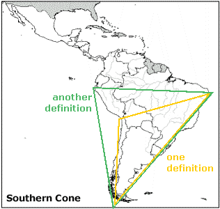
You should more specifically understand the following terms and their context with regard to the chapter and the region (this list is not entirely the same as that on page 167):
There are several words that may appear in the text or lecture but are never fully defined. You should understand these terms in case they are used in questions. I have made links to them on the net to help you define and understand them in other words. You should find some of these in your regular ol' dictionary, though.
Look at each map and try to understand the main idea. Look for general geographic patterns. Try not to get lost in details.
Figure 4.3. What is the relationship between the Andes and the continental plates? Note that much of the Amazon Basin includes portions of the Brazilian Shield. The Paraná Basalt Plateau is part of the Brazilian Shield. What is special about that region? The Paraná Basalt Plateau and the Pantanal are drained by which major river system?
Figure 4.10. Don't worry about the intricate details of all the little climate regions. Compare these climate regions to that of the U.S. in Figure 3.7. In this case, look particularly at the largest areas in eastern South America, Af, Aw, and Cfa. Any similarities with North America? Read the book text that goes along with this map to help you summarize it ("Climate," pp. 128-131). What does the book say particularly about the H climate found in the Andes?
Figure 4.12. Don't worry about all the intricate patterns here. Read the paragraphs to familiarize yourself with the issues. Note where those arrows point. Note the big block of green here, Tropical Forests, where is it generally?
Figure 4.16. Don't memorize every little red dot. Where are people generally living? Where are they absent? Read the caption.
Figure 4.17. Where is the retail? Where is the CBD? What is the spine? What's in the spine? What's going on in the periférico? Read the text on "Urban form" that goes along with this figure.
Figure 4.18. Please ignore the fact that the mapmaker does not seem to have put the state lines in the right places. What's the big story going on in the Amazon states in the last 40 years? Read the caption.
Figure 4.23. Don't try to memorize all the individual native languages. Where do they speak Spanish? Where do they speak Portuguese? Where are native languages generally spoken? Think in terms of broad patterns.
Figure 4.26. What is the significance of the Treaty of Tordesillas? How do the two maps in this figure "match up"? What happened to Gran Colombia and the United Provinces of Central America?
Figure 4.28. This map is extremely complicated. You should try to get summary material from it. Have there been many border conflicts in Latin America? Have there been movements towards the creation of supranational organizations in recent years? Read the caption.
Figure 4.34. Who are the major trading partners with Latin America (fat arrows)? How do these major trading partners compare with intra-regional trade (see box in lower left)?
Figure 4.36. What general trends do you see? Where is it dark? Where is it light? What does this indicate? Who lives in these places? Read the caption. Read the last paragraph on page 163 (and onto 164) that goes with this figure.
Figure 4.37. The colors on this map primarily represent change in births to women. Those that are darker have shown more decreases than those that are lighter. Those that are lighter may have had lower birth rates to begin with. Others may have maintained relatively high birth rates. Knowing what you know about Argentina and Guatemala, what do you think is going on each of those cases? The current TFR (1998) is listed under each of the bars indicating female participation in the labor force. Does that help you confirm your hypothesis about Guatemala and Argentina?
Be familiar with the following cities of Latin America. Where are they? Find them on the map. Know where they are. Find them on maps such as the climate map in Figure 4.10. Are they mentioned in the chapter or notes? What is important about each of these cities? In some cases you may find these cities mentioned several times in the notes and the text. In other cases, you might not find them at all. If not, ask yourself questions as you flip through the maps of the chapter, such as "What's the climate like in Buenos Aires?" and "What environmental challenges in Figure 4.12 apply to Buenos Aires?" and "What sort of biome is Lima in?" You should able to answer most of these questions. Particularly, focus in on regions and conditions mentioned in the textbook and in lecture, even when these cities weren't mentioned.
Part 2 now online.
Back to main page.
This page is http://www.geocities.com/lsugeog1001/sg-ex2.htm