
![]()
![]()
![]()
![]()
Let's start with a view of downtown Houston. I am sure those familiar with Houston will find that much has changed, even within the last few years.
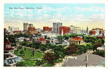
| Skyline 1920s |
Skyline 1940s |
Let us first take a look at the Houston skyline in the 1920s. We can compare it to the Houston skyline in 1940 when Houston was "America's fastest growing city." It is interesting to point out that in 1920, Texas' largest city was San Antonio, with a population of 161,379. Dallas was next with 158,976, while Houston was the third largest city with 138,276 in 1920, about the same population as today's City of Pasadena, a Houston suburb.
Several things should be pointed out in this postcard from 1940. This view is from the north of downtown, looking south-southeast. City Hall can be plainly seen in the upper right corner (number 8 on the card). Notice that there is no Interstate 45 curving around behind it on the west side of downtown to the south side of downtown. Notice also that the Shell building shown here (#14) is not the same Shell building that was the tallest building in Houston for a number of years.
Petroleum is the new lifeblood of this town in the early twentieth century. This is apparent when one notes that this card shows the Humble Building (later Exxon), Texas Co. Building (later Texaco), the United Gas Building, and the Gulf Building (later purchased by Chevron). Of course, on the left is the Petroleum Building (20).
![[Bird's Eye View of Houston Texas (ca. 1910)]](birds.jpg) Taking a closer look, around 1910 (the card
is postmarked 1913), we can see several buildings that reappear several times in Houston postcards. The postcard to the
left shows a view from Prairie and Main, looking south-southwest (well, actually west-southwest considering that on
Houston's downtown grid "south" is actually southwest). Visible in this postcard is the Binz Building, with the large sign
for the Lawrence Barrett Cigar, "The largest portrait ever painted, the best cigar ever made." Also visible in this card
is the Rice Hotel (see also) with the large Richelieu Beer sign on top, "Made in Houston." The
buiding in the lower right corner is the Lumberman's National Bank (see Second National Bank
Building). Also visible are [C]ockrell & Bonner Druggists and the Columbia Shoe Co. One building appears to read
Gorman & McAughan Jewlers & Brokers. On the right side of Main, at the corner of Capitol Street and Main Street,
you can just make out the sign for Capitol Hotel.
Taking a closer look, around 1910 (the card
is postmarked 1913), we can see several buildings that reappear several times in Houston postcards. The postcard to the
left shows a view from Prairie and Main, looking south-southwest (well, actually west-southwest considering that on
Houston's downtown grid "south" is actually southwest). Visible in this postcard is the Binz Building, with the large sign
for the Lawrence Barrett Cigar, "The largest portrait ever painted, the best cigar ever made." Also visible in this card
is the Rice Hotel (see also) with the large Richelieu Beer sign on top, "Made in Houston." The
buiding in the lower right corner is the Lumberman's National Bank (see Second National Bank
Building). Also visible are [C]ockrell & Bonner Druggists and the Columbia Shoe Co. One building appears to read
Gorman & McAughan Jewlers & Brokers. On the right side of Main, at the corner of Capitol Street and Main Street,
you can just make out the sign for Capitol Hotel. ![[1891 Houston Map]](mapricex.gif) The tall, cream-colored
building on the right side of the postcard is the Houston Chronicle building. When this this
building first opened, it was home of the Houston Club on the tenth floor. To the right is a
map showing the area in 1891.
The tall, cream-colored
building on the right side of the postcard is the Houston Chronicle building. When this this
building first opened, it was home of the Houston Club on the tenth floor. To the right is a
map showing the area in 1891.
On the next page, we'll take a look at Main Street.
The white border card of the 1920s Houston skyline is postmarked 1925 in Houston. It was published
by Seawall Specialty Co., Galveston, Texas. The linen postcard of the 1940 skyline is a C.T. Art-Colortone, published by
Seawall Specialty Co. of Houston and Galveston.
This HTML page is copyright ©1998, 1999 Leslie Carl Seiler. All rights reserved. This page was updated 23 May
1999.
![]()